Hurricane Francine: Latest Updates and Impacts
As Hurricane Francine approaches the Gulf Coast, particularly Louisiana, the situation is becoming increasingly critical. With the storm expected to make landfall later today, residents are bracing for potentially life-threatening conditions. Here’s a comprehensive overview of the latest developments regarding Hurricane Francine.
Current Status of Hurricane Francine
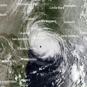
Hurricane Francine has intensified into a Category 1 hurricane, with maximum sustained winds reaching 75 mph. The storm is projected to make landfall between Avery Island and Houma, Louisiana, between 4 p.m. and 8 p.m. local time today. The National Hurricane Center (NHC) has issued warnings about the potential for dangerous storm surges and strong winds that could lead to significant flooding and power outages.
Key Updates:
- Landfall Timing: Expected between 4 p.m. and 8 p.m. today.
- Wind Speeds: Currently at 75 mph, with potential for further strengthening.
- Storm Surge: Life-threatening surges are anticipated, with some areas expecting up to six feet of water.
Evacuations and Preparations
In anticipation of the storm, many coastal residents have begun to evacuate. Louisiana Governor Jeff Landry has mobilized the National Guard, deploying nearly 400 high-water vehicles to assist in rescue operations and evacuations. Local authorities are urging residents to take the storm seriously and prepare for possible power outages and flooding.

Evacuation Orders:
- Residents in low-lying areas are advised to evacuate immediately.
- Shelters have been set up in various locations for those needing refuge.
Forecast and Potential Impacts
Meteorologists are closely monitoring the storm's path, which is expected to move northward across Mississippi after landfall. The NHC has indicated that if Francine continues to strengthen, it could reach Category 2 status before making landfall.
Potential Impacts Include:
- Severe Wind Damage: Gusts could reach 80-100 mph in some areas, particularly if the storm's eyewall passes directly over populated regions.
- Flooding: Heavy rainfall is expected, exacerbating the risk of flooding in already vulnerable areas.
- Power Outages: Widespread outages are likely due to downed power lines and infrastructure damage.
Live Updates and Resources
For those seeking real-time updates, several news outlets are providing continuous coverage of Hurricane Francine:
- NBC News: Live Updates on Hurricane Francine
- Weather.com: Hurricane Francine Live Updates
- ABC News: Hurricane Francine Live Updates
- The New York Times: Live Updates on Hurricane Francine

As Hurricane Francine approaches the Gulf Coast, it is crucial for residents to stay informed and heed the warnings from local authorities. The storm poses significant risks, including storm surge, high winds, and flooding. Preparations are underway, and the community is urged to prioritize safety as the situation develops.
Stay tuned for further updates as the storm progresses, and ensure you have a plan in place for your safety and the safety of your loved ones.